|
[Links][ MalaysiaMap][OurGroup][About Fall][Beautiful Fall][Back-Index][Type]
| Determine the Size of Waterfalls |
 |
It is meaningless to describe the
size of falls without benchmarking falls. Since such
measurement is little known. We momentarily fill the gap
with our own yardstick.
At least, we
were able to get on comparing all those waterfalls seen by us in a
same consistent manner
|
 |
| In Malaysia, the Peninsula is about
350 kilometer wide with the Central Range in e the
middle. The
large rivers running only a couple of hundred kilometers
are approximately 50-100 meters
wide. |
|
|
We are of the opinion that
using the flow rate at the waterways is technically
consistent. By estimating this flow rate, we can overcome
inconsistencies caused by optical illusion generated at
dramatic falls. This is how our table would look like.
| Usual terms used |
Brook |
Stream |
Small river |
Common River |
Main River |
| Classification |
Class 1 |
Class 2 |
Class 3 |
Class 4 |
Class 5 |
| Average width |
1-2 meter |
3-5 meters |
6-8 meters |
9-12 meters |
13- 20 meters |
| Average depth |
0.5 meters |
0.5 meters |
0.5 meters |
0.5 meters |
over 1 meter |
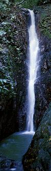
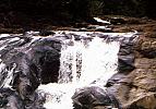
Example of how we had apply this table. Without optical
references within the pictures, the photographs on the left would show how a class 2 river
would look like while the photographs of the rapid on the right would be
a class 4 river.
There is no
notable waterfalls in class 6 (large river) in
Peninsular. There are large river associated with
white activities, such as Lata Jeram Besu in
Benta together with a few other rapids in Sungei Jelai or Nengerri
. So far there is no mention of waterfalls among these stretches.
| The table thought
of by us is used purely as a guide to the volume of water flowing along
the same river- usually measured at a sedated stage.
In real
life- Waterfalls located in upper reaches are no where
close to such conditions i.e. clinical or timid environments. Most of them are water rushing down a
slope, scattered and broken into streaks.
|
On other matters,
|