| Accessability: Easy |
| Picture |
Name/Location |
Type |
Activities |
Description |
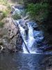 |
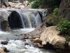
Jeram Linang Between Jertih and Machang |
Multiple falls |
Picnic
Swimming
Trekking
|
Popular nature park with some small waterfalls Permit ?? Last update March 2005 |
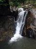 |
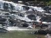
Jeram Pasu Eight km south-west of Pasir Puteh |
Single fall |
Picnic
Swimming
Camping
|
A popular waterfall near Kota Baharu. A bit over-developed, but a nice destination for a relaxing bath Permit ?? Last update October 2006 |
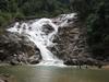 |
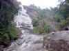
Lata Berangin 20 km south-east of Kuala Krai |
Single fall |
Picnic
Swimming
|
A powerful fall in a remote region. Easy access Permit ?? Last update February 2007 |
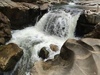 |
Lata Janggut 12 km south-west of Jeli |
Cascades
Single fall |
Picnic
|
Easy access. Waterfall not spectacular, but beautiful erosion of the rocks Permit ?? Last update October 2015 |
 |
Lata Kertas 20 km south of Dabong |
Rapids
Single fall |
Picnic
Swimming
|
Easy access from the D29 road. Rundown place, but the waterfall is nice Permit ?? Last update October 2015 |
 |
Lata Rek Between Gua Musang and Kuala Krai |
Cascades
|
Swimming
Camping
|
Seasonal water flow.
Impressive when flow is big enough
Permit ?? Last update March 2005 |
| Accessability: Moderate |
| Picture |
Name/Location |
Type |
Activities |
Description |
 |
Stong Fall near Dabong |
Multiple falls |
Trekking
Camping
|
Also known as Jelawang Fall. Supposedly the tallest waterfall in South-East Asia
Permit ?? Last update July 2011 |